MAP THE WORLD WITH GEOBLAZOR
Enterprise GIS Framework for .NET
GeoBlazor is the only .NET library that delivers enterprise GIS functionality to Blazor applications. Beyond basic mapping, GeoBlazor unlocks the full ArcGIS Maps SDK through C# and Razor syntax.
Trusted by


See GeoBlazor in Action!
Explore working examples that demonstrate GeoBlazor's mapping capabilities. Each sample includes complete C# and Razor code you can run immediately in your own Blazor application.
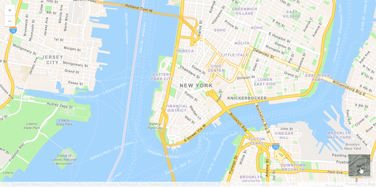
Basemap Toggle
Switch between different basemap styles including streets, satellite, and terrain. This sample demonstrates how to implement dynamic basemap switching in GeoBlazor applications.
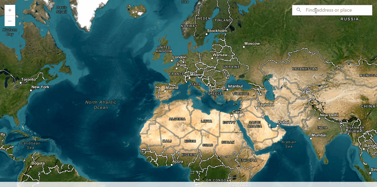
Location Search & Geocoding
Find addresses, landmarks, and places of interest with intelligent search functionality. This sample shows how the GeoBlazor Search widget enables location discovery and automatic map navigation.
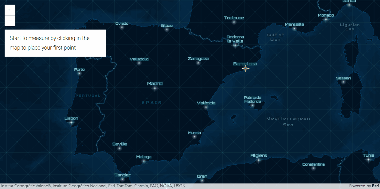
Measurement Tools
Calculate distances, areas, and elevation profiles directly on the map. This sample demonstrates GeoBlazor's measurement widget for quick spatial analysis and dimension calculations.
Bookmarks
Save and navigate to important map locations with spatial bookmarks. This example shows how to create, manage, and switch between predefined viewpoints in your GeoBlazor application.

Built with GeoBlazor
Our customers are developing powerful mapping applications across diverse industries. Here are some real-world projects currently in development:
Law Enforcement Mapping Application
A mobile law enforcement application that uses GeoBlazor to display points of interest, jurisdictional boundaries, and critical locations. This Blazor-based phone app provides officers with real-time geographic awareness essential for public safety operations.
Enterprise Reporting Application for City of Eugene
An enterprise-level application developed for the City of Eugene that combines GeoBlazor mapping with comprehensive reporting capabilities. This cross-platform solution built with .NET MAUI and Blazor enables city personnel to generate location-based reports and visualize municipal data.
Enterprise Application for City of Eugene
A comprehensive enterprise-level application developed for the City of Eugene's municipal operations. This GeoBlazor implementation provides city administrators with integrated mapping capabilities for various municipal services, combining spatial analysis with administrative workflows.
Blazor Hybrid Apps for City of Scottsdale
A suite of Blazor hybrid applications developed for the City of Scottsdale's municipal operations. These GeoBlazor implementations provide city departments with integrated mapping capabilities across web and mobile platforms, demonstrating how local governments can modernize their GIS infrastructure.
Parcel Maps for State of Texas
A statewide parcel mapping application that provides comprehensive property boundary visualization for Texas. This GeoBlazor-based system enables government personnel and citizens to access parcel data, property boundaries, and land ownership information through an interactive web mapping interface.
Texas Department of Transportation Data System
A data management application developed for the Texas Department of Transportation that handles 300 petabytes of transportation data. This GeoBlazor implementation provides ArcGIS map controls, HeatMap visualization, and lookup features for massive datasets with integration to Azure Database and Cosmos DB.
Campus Incident Reporting with Floor Plans
A building and campus safety application that reports incidents such as slip and fall accidents using detailed floor plan mapping. This GeoBlazor implementation provides university safety personnel with indoor mapping capabilities to identify problem areas across multiple buildings and floors.
Multi-Layer Public Transport Map
A public transportation mapping application that displays various markers, GeoJSON objects, and multiple data layers for transit systems. This GeoBlazor implementation incorporates real-time weather data, enabling transit planners and riders to visualize routes, stops, and service information with environmental context.
Construction Project Follow-Up System
A project management application that uses GeoBlazor to track and monitor construction projects geographically. This system enables construction managers to visualize project locations, monitor progress across multiple sites, and coordinate resources using spatial analysis and interactive mapping.
Pipeline Infrastructure Display System
A utility infrastructure application that displays pipeline networks and related geographic data. This GeoBlazor implementation enables utility companies to visualize underground infrastructure, manage asset information, and plan maintenance operations using enterprise GIS mapping.
Esri Migration from Smallworld
A utility company application migrating from Smallworld GIS to Esri's ArcGIS platform using GeoBlazor. This project demonstrates how organizations can modernize legacy GIS systems by rebuilding functionality in Blazor, accessing enterprise-grade mapping tools and spatial analysis through a modern .NET web framework.
Oil & Gas Data Management Software
A free open-source web-based data management system designed specifically for the oil and gas industry. This GeoBlazor application provides energy companies with geographic visualization of well locations, pipeline networks, and production facilities using enterprise GIS capabilities in specialized industry applications.
Multi-Layer WFS/WMS Viewer
A geographic information system viewer that displays multiple WFS (Web Feature Service) and WMS (Web Map Service) layers. This GeoBlazor application enables GIS professionals to overlay and analyze various data sources from different web services, demonstrating interoperability between ArcGIS and standard OGC web services.
Device Location Mapping Tool
A utility application that visualizes the placement and location of devices across geographic areas. This GeoBlazor implementation enables organizations to track equipment deployment, plan device installations, and manage asset locations using interactive ArcGIS mapping.
Waste Management Route Optimization
A route optimization application designed for waste management companies in Germany. This GeoBlazor solution enables logistics planners to create efficient collection routes, visualize service areas, and optimize fleet deployment using enterprise GIS capabilities, all implemented in Blazor to eliminate JavaScript development requirements.
Agricultural Equipment Tracking System
A web application designed to track tractor locations and movements in real-time for agricultural operations. This GeoBlazor implementation provides farmers and fleet managers with visibility into equipment positioning, field coverage, and operational efficiency using ArcGIS mapping integrated into a Blazor interface.
Real-Time IoT Vehicle Tracking System
A real-time tracking system for IoT-enabled vehicles and robots. This GeoBlazor application visualizes device locations, movement patterns, and operational status on interactive maps, demonstrating how enterprise GIS capabilities can integrate with Internet of Things platforms to provide geographic awareness.
Supply Chain Geographic Visualization
A supply chain management application that leverages GeoBlazor to visualize logistics and distribution networks. This enterprise system provides supply chain managers with geographic insights into transportation routes, warehouse locations, and delivery zones using ArcGIS mapping integrated into a Blazor web application.
Multi-Layer Public Transport Map
A public transportation mapping application that displays various markers, GeoJSON objects, and multiple data layers for transit systems. This GeoBlazor implementation incorporates real-time weather data, enabling transit planners and riders to visualize routes, stops, and service information with environmental context.
Multi-Technique Storm Tracking System
A meteorological application that integrates multiple mapping techniques to track storm systems in real-time. This GeoBlazor implementation provides weather monitoring capabilities with support for various data visualization methods, enabling meteorologists to analyze storm patterns and predict weather events using enterprise GIS functionality.
Aquatic Disease and Pathogen Tracker
An environmental monitoring application that maps locations of aquatic diseases and pathogens in water bodies. This GeoBlazor implementation enables environmental scientists and public health officials to visualize disease outbreaks, track contamination spread, and analyze spatial patterns of waterborne pathogens using enterprise GIS tools.
Climate Data Visualization Tool
A data visualization application that displays custom markers on maps based on LAT/LON climate data. This GeoBlazor implementation enables climate researchers to plot weather stations, temperature readings, and environmental sensor data using ArcGIS mapping capabilities integrated into a Blazor web application for scientific analysis.
Honduran Farming Georeference Project
A georeferencing application designed for farmers in Honduras to map and manage agricultural lands. This GeoBlazor implementation provides farming communities with tools to document field boundaries, crop locations, and agricultural resources using accessible web mapping technology built on the ArcGIS platform.
Construction Project Monitoring Portal
A web portal designed to monitor and follow up on multiple construction projects across different geographic locations. This GeoBlazor implementation enables project managers and stakeholders to track construction progress, visualize project sites, and coordinate activities using interactive ArcGIS mapping.
Interactive Presentation Mapping Tool
A presentation application that allows users to interact with maps and create annotations during live presentations. Built with GeoBlazor, this tool enables presenters to mark locations, add notes directly on interactive maps, and engage audiences with real-time geographic data visualization during conferences and meetings.
Disc Golf Player Trajectory Analysis
A sports analytics application that tracks and visualizes player movements in disc golf, including tee pad locations, basket positions, and walking trajectories. This GeoBlazor implementation adds advanced data visualization such as heart rate intensity overlays, demonstrating how enterprise GIS capabilities can enhance sports performance analysis.
Motocross Bike Performance Analyzer
A testing application that analyzes data logged from motocross bikes during races and practice sessions. This GeoBlazor implementation visualizes rider paths, speed variations, and performance metrics on geographic terrain, providing racers and teams with spatial insights into bike performance and racing lines.
Women's GPS Safety Application
A personal safety application designed for women that incorporates GPS tracking and location sharing. This GeoBlazor implementation provides real-time location awareness and emergency communication features through interactive mapping, demonstrating how enterprise GIS capabilities can be applied to personal safety solutions.
Multi-Campus Church Location Maps
A mapping application designed for a large church organization with over 25 campuses. This GeoBlazor implementation helps members and visitors locate church facilities, view campus boundaries, find parking, and access building information across multiple geographic locations through an interactive web map.
Dynamic Mapping Application
A web-based application that demonstrates GeoBlazor's ability to handle dynamic content and real-time map updates. This implementation showcases how developers can build interactive mapping experiences in Blazor that respond to user input and data changes, leveraging the full ArcGIS Maps SDK through C# and Razor syntax.
C# Web Application with GeoBlazor
A web application that integrates GeoBlazor mapping functionality into existing C# codebases. This implementation demonstrates how .NET developers can add enterprise GIS capabilities to established web applications without learning JavaScript, using familiar C# and Razor syntax to implement ArcGIS mapping features.
Blazor/Maui Hybrid with Shared Components
A cross-platform application using .NET MAUI and Blazor with shared Razor components for web and mobile deployment. This GeoBlazor implementation demonstrates code reuse across platforms, allowing developers to build mapping functionality once and deploy to both web browsers and native mobile applications.
.NET Maui Geo-Tagging Application
A mobile geo-tagging application built with .NET MAUI that enables users to attach geographic coordinates to photos, notes, and observations. This GeoBlazor implementation demonstrates how developers can create location-aware mobile apps using Blazor components and ArcGIS mapping in a cross-platform .NET environment.
ArcGIS Platform Investigation
An exploratory project investigating ArcGIS capabilities and integration possibilities with Blazor. This development effort demonstrates how developers can evaluate GeoBlazor for potential enterprise implementations, testing various mapping features and spatial analysis tools available through the ArcGIS Maps SDK in a .NET environment.
Custom Blazor Mapping Solution
A proof-of-concept application exploring custom mapping solution integration with Blazor. This GeoBlazor implementation investigates how enterprise GIS capabilities can be embedded into existing Blazor applications, testing various customization options and integration patterns available through the ArcGIS Maps SDK.
GeoBlazor Around the World
From government agencies to startups, developers across the globe are building powerful mapping applications with GeoBlazor. See where our community is making an impact.
Support & Resources
Get help with you GeoBlazor implementation through community and direct support channels available for both Core and Pro users.
GeoBlazor Core
Community Support
- Community Discord server
- GitHub issues & discussions
- Comprehensive documentation
- Code samples library
- Community-driven support
GeoBlazor Pro
Professional Support
- Everything in Core, PLUS:
- Dedicated support credits
- Priority email support
- Direct access to dev team
- 24-48 hour response time
Stay in the Know
New features and bug fixes as well as additional samples are added regularly. Be the first to know when a new release is available by subscribing to our notifications.

Browse our code, submit an issue, or see what we've been building.

We check this inbox
more than we should.

Prefer talking to a real human?
We'd love to hear from you!